In late 2004, the world watched as one of the biggest natural disasters took place across the Indian Ocean.
A 9.1-magnitude earthquake caused the deadliest-ever tsunami, which ravaged the unsuspecting villages and communities along the surrounding coasts of the ocean.

The disaster killed around 230,000 people and injured and displaced hundreds of thousands more. The earthquake that provoked the deadly tsunami stands today as the third largest in the world since 1900, exposing just how powerful it was.
It took years to clean up the destruction and devastation of the affected places, which were primarily the coastal areas of Indonesia, Sri Lanka, India, and Thailand.
As well as the human fatalities, the disaster also destroyed 139,000 houses, almost 74,000 hectares of agricultural land, thousands of schools, hundreds of health facilities, and eight airports and airstrips.
Let’s revisit the cataclysmic earthquake and tsunami twenty years after it occurred.
How The Disaster Started
The devastation began on Boxing Day 2004 off the coast of Sumatra Island, Indonesia. Almost 20 miles below the ocean floor, the Indian and Burma plates subducted.
This means that the tectonic plates suddenly collided, and the Indian plate was thrust beneath Burma, causing an 800-mile rupture.
To put this in perspective, the rupture was about the same length as Texas.
This, in turn, created a tremendous earthquake, which is estimated to have released the equivalent energy of 23,000 Hiroshima-type atomic bombs. The quake hit 9.1 on the magnitude scale.
Anything 7.0 to 7.9 on the scale is classed as a “major earthquake” that causes “serious damage.” Anything labeled 8.0 or greater is an earthquake that can “totally destroy communities near the epicenter,” which is exactly what happened.
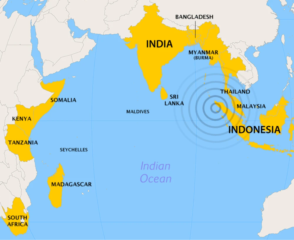
The earthquake’s effects were felt in nearby Indonesia, Thailand, Sri Lanka, the Maldives, Singapore, and India.
As the plates met, the lengthy fault line where the Indian and Australian tectonic plates collided caused the ocean floor to rise by an astonishing 40 meters.
The earthquake itself was bad enough, but the tsunami it caused afterward would truly wreak havoc. First, it hit Banda Aceh, a city located on the island of Sumatra.
The western part of Banda Aceh is just about flat, meaning there was little to no respite from the gigantic waves that hit the communities that lived there.
The only forewarning locals had about the imminent tsunami was that, just after the earthquake, the sea receded and exposed the seabed.
This unusual event saw locals go and pick up the washed-up fish, only to be greeted with a “black giant” in the distance, which was, in fact, a huge wall of water heading toward them.
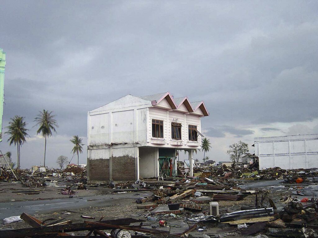
Before they knew it, their city was inundated with water. Buildings, even strong, fortified concrete ones, were reduced to rubble. The city was submerged in water up to the second floor.
A small coastal area called Lhoknga, eight miles southwest of Banda Aceh, was next on the tsunami’s hit list. Just as before, the sea receded for a short time before residents saw the giant waves in the distance. The first bout of waves was devastating, some reaching almost 100 feet high.
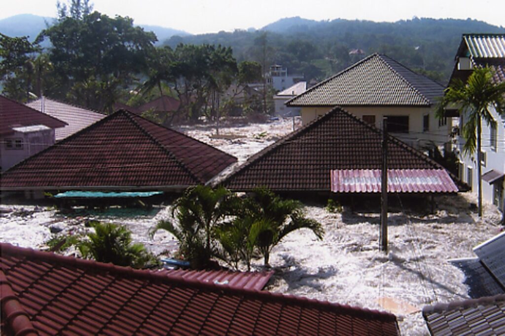
Lhoknga would see the highest tsunami waves, followed by those who lived on the Banda Aceh coast. Krueng Raya, a small fishing city, saw waves of 20 feet.
The country of Sri Lanka is located about 1,100 miles from Sumatra, where the earthquake originated. It took two hours for the tsunami to reach here, though the violent waves still caused plenty of damage.
The waves, traveling at 500 miles per hour, took 35,322 lives in Sri Lanka. Around 90,000 buildings and countless wooden houses were destroyed by the giant waves.
Around the same time, the tsunami hit the southwestern coasts of Thailand. It was a popular time for tourists in Thailand, practically in Phuket, which was badly damaged. The tsunami killed over 8,000 people when it reached Thailand. The waves in Khao Lak, a quiet coastal area, reached up to 33 feet.
India was hit around two hours after the earthquake also, taking 16,269 lives.
Somalia’s death toll reached 289, the Maldives saw 108 deaths, Malaysia 75, Myanmar 61, and Tanzania 13. Bangladesh, Seychelles, South Africa, and Yemen all saw two fatalities from the effects of the tsunami.
The After Effects Of The Tsunami
There was an overwhelming international response to provide rescue and relief to the affected countries and communities, and the donations totaled $6.25 billion.
Initially, this money was used to ensure the immediate rescue and safety of those affected. It helped create safe shelters and pay for emergency supplies such as food and medical kits. The funding also helped build long-term shelters for survivors, with almost 14,000 homes built in Aceh alone.
Then, there was the clean-up of the tsunami to contend with.
The debris from the disaster caused the destruction of the environment and proved to be tricky to dispose of. So, money was pumped into an environmentally economical way of removing the debris.
This meant things like broken concrete and bricks were collected and crushed and were used to help rebuild roads. The initial clean-up began with a “food for work” trade-off with survivors who were able to do so.
They were given food and shelter in return for their help in rebuilding the community.
However, there was no escaping that the initial clean-up of the affected areas had seen waste moved from one site and simply dumped in another. In some instances, waste from the disaster had been collected and burned, leading to an unwanted negative impact on the environment.
Then there was the contaminated soil and water, both of which caused huge problems for the agricultural areas as well as the urban areas. Sewage found its way into the water supply, as did oil and debris.
Much of the land in each affected country was now contaminated by salt water, their forests were damaged, and fragile ecosystems were irreparably harmed.
As the clean-up ensued, the reality of the disaster-hit those affected by it. One man lost almost 30 members of his family in the tsunami, one of whom was his child. Some individuals had survived the initial disaster but were left with life-altering injuries or illnesses as a consequence of the tsunami.
Many survivors, understandably, were left with PTSD from the horrors they saw and endured during the terrifying event.
With donations coming in at a rapid pace, the affected countries quickly purchased the materials to build new homes and health facilities. As such, 80% of the individuals who owned a home that was destroyed had a replacement within five years of the tsunami.
It took a while for an accurate death toll figure to be calculated since many individuals were classed as missing in the aftermath of the disaster. Years after the tsunami, it was estimated there were 230,000 fatalities from 14 affected countries across the Indian Ocean.
This figure included the 9,000 foreign tourists who hailed from dozens of other nations. This makes the 2004 Indian Ocean tsunami and earthquake the worst natural disaster that affected such a large number of countries.
Since the disaster seemingly came out of nowhere without warning, how can such a tragic natural disaster be prevented from happening again?
Preventing Another Disaster
The devastation of the disaster prompted the United Nations to agree that the detection and warning of underwater earthquakes is paramount in preventing another huge loss of life.
Had ocean floor earthquake sensors been in place at the time of the 2004 earthquake, people would have been given some warning and thus time to evacuate.
The only way forward was to implement an early warning system that could relay an impending earthquake to citizens. Other methods to lessen the damage included the use of sea walls, which would, at the very least, delay flooding and offer more time for evacuation.
So, in January 2005, after a UN meeting, the International Early Warning Programme was introduced. In June 2006, 17 seismic VSAT stations with two central recording stations were installed to provide a seismic event alert to scientists within two minutes of its occurrence.
In 2012, the system’s capabilities were tested when another Indian Ocean earthquake occurred. Its magnitude was recorded as 8.6, and yet again struck near the Indonesian province of Aceh.
The system alerted the Indian islands of Andaman and Nicobar within eight minutes, allowing warning sirens to alert civilians.
A repeat of the 2004 tsunami was expected.
As some sirens went off, a batch of warning sirens in Aceh were delayed by about 20 minutes because the earthquake had caused a failure in their electrical grid.
Thankfully, the anticipated tsunami never took place.
The possibility of another disaster exposed some failures in the system, namely that the system had no means to predict tsunamis from volcanic eruptions. After the 2018 Sunda Strait tsunami, which caused 437 casualties, 13,000 injuries and displaced around 33,000 people, this weakness was amplified.
Since then, the Indonesian government installed sea level sensors to ensure they can foresee any potential tsunami from a volcanic eruption.
Today, Australia, Indonesia, and India are responsible for spearheading tsunami warnings to the 28 countries that ring the Indian Ocean. Should another terrible natural disaster occur, these countries now have better protection and evacuation warnings in place.
Sources
https://www.noaa.gov/jetstream/2004tsu_max
https://www.mtu.edu/geo/community/seismology/learn/earthquake-measure/magnitude/
https://www.hindawi.com/journals/emi/2011/920813/
https://www.preventionweb.net/news/indonesia-battered-tsunamis-how-prepared-india-repeat-2004


Leave a comment