How far apart are Russia and America? Most people assume that the two countries are separated by the Bering Strait that runs between Alaska and Siberia. At its narrowest point, this is around 55 miles wide.
But just imagine if there was a place that is part of the United States where you could step outside your back door and look directly into Russian territory.
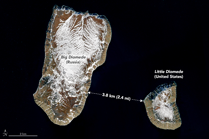
Few people realize that such a place actually exists – the Diomede Islands are a pair of small, barren, rocky islands in the middle of the Bering Strait, separated by just 2½ miles of ocean.
One is American, the other Russian. In the winter, when ice forms, it would be almost possible to walk between these islands, but if you were to do that, you’d be crossing not just an international border but also the International dateline.
This is the odd story of Tomorrow Island and Yesterday Island and the narrowest part of the border between America and Russia.
Discovery
In 1648, a Russian explorer, Semyon Ivanovich Dezhnyov, set out on voyage of exploration in Siberia in a fleet of five small Koch boats, wooden one or two masted sailing ships.
Dezhnyov, a government official in the region, had helped to found the town of Srednekolymsk on the Kolyma River, at that time the easternmost settlement of the Russian Empire.
The purpose of the voyage was to find sources of furs in the region, but it was a disaster. All the ships were wrecked and it wasn’t until 1650 that Dezhnyov and a handful of survivors were finally rescued.
Dezhnyov did report one interesting fact: he had discovered two small, barren islands in the ocean off Siberia. These didn’t seem terribly important at the time, and there were no subsequent efforts to locate them.
It wouldn’t be until 75 years later that a Danish explorer, Vitus Bering, in the service of the Imperial Russian Navy, was sent on a voyage to explore the body of water that separates Siberia and Alaska.
The Russian Tzar, Peter the Great, was interested in expanding Russian territory into North America and wanted to know whether there was a land route from Siberia to Alaska.
Bering (whose name was given to the area he explored, the Bering Strait) was able to report that there wasn’t a land route, but he did rediscover the two small islands that lay halfway between Siberia and North America.
He sighted the islands on August 16th, 1728. In the Russian Orthodox Calendar, this is the feast day of Saint Diomedes of Tarsus, so Bering named these the Diomede Islands.
Four years later, in 1732, Russian settlers arrived in what they called Russian America, a part of present-day Alaska, which would remain Russian territory until it was sold to the United States almost 150 years later.
The People, History, And Climate Of The Diomede Islands
The people who live on the Diomede Islands are Ingalik, Native Americans who mostly live in what is now Alaska. The first contact with these people was made by Russian settlers in the early 19th century on the lower Yukon and Innoko rivers.
Later, it would be discovered that the same people inhabited the two small Diomede Islands. The term Ingalik comes from a Russian word, “Inkiliki,” but these hardy people call themselves the “Deg Hit’an” (the People from here).
It is believed that the Ingalik people have inhabited this region for more than 3,000 years.
The region in which the islands are located is subarctic, subject to intense cold, frequent storms, dense fog, and heavy snow.
In the summer, the temperature averages 5 to 10˚C. In the winter, the temperature rarely rises above -14˚C and often drops to -25˚C or colder.
The two Diomede Islands lie in the middle of the Bering Strait, half way between Alaska and Siberia. The larger of the two covers 11 square miles and the smaller less than three.
Both were claimed by Russia in the 18th century, but when Alaska was sold to the United States in 1867, it was agreed that the smaller northern island, Little Diomede, would become American territory while the larger southern island, Big Diomede (also known in Russia as Ratmanov Island) would remain Russian territory.
The border between Russian and American territory would, therefore, run through the narrow channel that separates the islands.
In 1884 the International dateline was established. This was a point halfway around the world from the Prime Meridian that passes through Greenwich, England and would mark the boundary between two consecutive calendar dates.
This line passes through largely uninhabited regions of the Pacific Ocean, and when it was established, it was agreed in the north that it would follow the boundary between Russian and American territory.
For this reason, the international dateline passes directly between the two Diomede Islands, meaning that the time on Big Diomede is always 21 hours ahead of the time on Little Diomede.
That’s why these islands are sometimes known as Tomorrow Island (Big Diomede) and Yesterday Island (Little Diomede).
Recent History
When the United States and the Russian Empire agreed to establish a boundary running between the Diomede Islands in 1867, that didn’t seem particularly important – America generally enjoyed friendly relations with the Russian Empire.
Then, in 1917, Russia was thrown into turmoil by a revolution that saw the Tzar deposed and executed, and then a bloody civil war was fought between the Reds, supporters of the new Bolshevik regime, and Whites, supporters of the Russian monarchy.
In 1922, Russia became the most important member of the new Union of Soviet Socialist Republics (USSR).
There were worldwide fears that the Communism that underpinned the USSR might spread to other areas, and in the USSR, fears that America and other nations might try to destroy the new state.
The relationship between Russia and America became one of distrust and hostility on both sides.
During World War Two (1939 – 1945), that briefly changed as America and Russia became allies in the fight against Nazi Germany and the Japanese Empire.
During the war, Big Diomede became a Russian military base, and the Ingalik people living there were forcibly removed to the mainland.
After World War II, the relationship between America and the USSR deteriorated rapidly again into what became known as the Cold War, a period of hostility that (just) stopped short of military confrontation.
The Diomede Islands found themselves on the front line of this confrontation. Anyone attempting to cross from Little Diomede to Big Diomede was likely to be arrested or even shot.
The collapse of the USSR in the early 1990s brought an improvement in the relationship between the new Russian Federation and the United States.
Today, Big Diomede is said to be the location not for a military base but a weather station, but it is still impossible to travel between the islands without risking arrest by border guards of the Russian Federation.
Climate Change
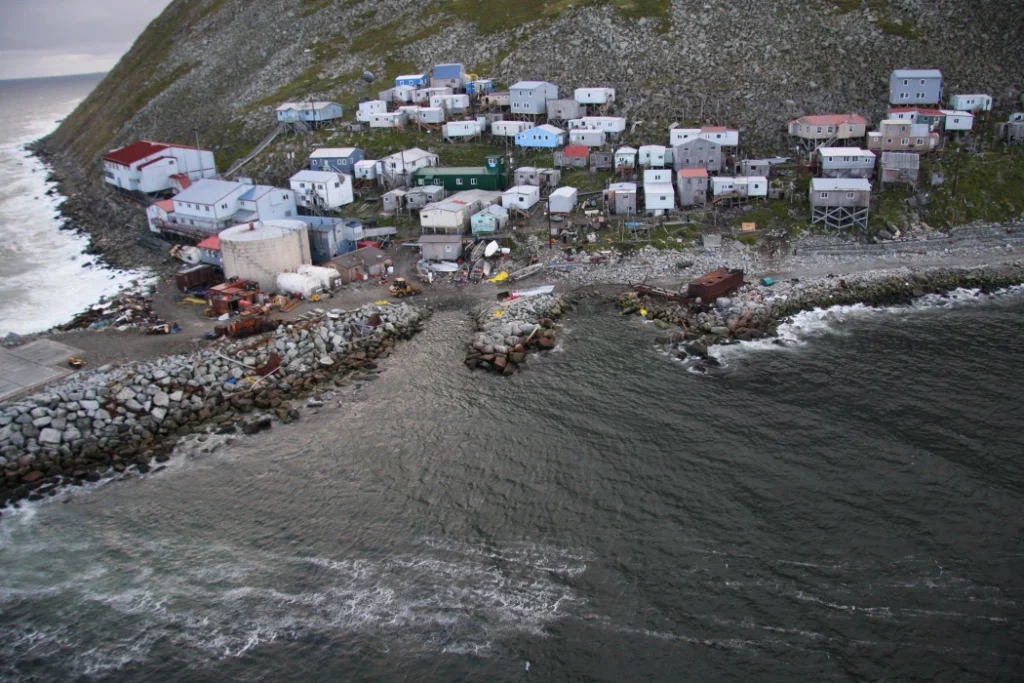
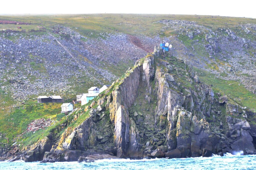
Little Diomede contains a single town, Iŋaliq, that is the home to fewer than 100 people. There is a small school and a single store but transport to and from the island is a major and continuing problem.
There is no port and no airport in Little Diomede. Once a year, in the summer months, a cargo ship brings supplies to the island that are laboriously lifted off using cranes. For most of the island’s recent history, there was one other way to reach Little Diomede: by aircraft.
In the winter, sea ice up to four feet thick was graded to provide a safe and durable runway for small aircraft, providing the island with a vital air link.
In 2018, a storm broke up the ice and destroyed the runway. It has never returned, something that has not happened within living memory.
Now, the only way to reach the island is by ship or helicopter, and consistently bad weather makes both forms of travel hazardous and unreliable.
The sea ice also provided islanders with a way to reach the ocean safely, to fish and to catch crabs. The disappearance of the ice, believed to be caused by global warming, means that this is now impossible.
There are a few commercial fishing boats based on Little Diomede, but far fewer than previously, and even this small industry is now in serious decline.
Conclusion
The Diomede Islands are truly unique. These small, rocky islands are separated by less than three miles, but one is in America and the other in the Russian Federation.
Probably less than 200 years ago, there was a sand-bar between the islands, making it possible to walk from one to the other. That has now gone and the international situation means that travel between the islands is impossible.
Life is tough for the inhabitants of Little Diomede. Travel to and from the island is difficult, medical facilities are limited, supplies are intermittent, and the disappearance of the sea ice in 2018 removed the island’s only reliable air link with the US mainland.
Like many Native Americans, the Ingalik people of Little Diomede have a lifestyle closely connected to the local ecosystem.
Climate change means that the ecosystem is changing, and no one knows what this means for the long-term future of this remote island.
Sources
https://arcticportal.org/education/quick-facts/63-government-and-policies/3453-diomede-islands


Leave a comment