On May 18th, 1980, the sun broke across the Cascade Mountains in Washington State at 5:36 a.m. to reveal a calm and cool morning.
For days, scientists, journalists, photographers, and thrill seekers had been camped a few miles from the summit of Mount St. Helen’s in anticipation of the widely predicted volcanic eruption.
One of those people was freelance photographer Robert Emerson Landsburg from Portland, Oregon. He had driven his 1969 Dodge station wagon up to South Fork Toutle River to photograph the mountain.

The night before the eruption, Landsburg made camp and wrote in his journal about the volcano, “Feels right on the verge of something.”
Little did Landsburg know that his intuition would be devastatingly spot on.
Louwala Clough – The Native American Legend
Native American lore contains numerous legends explaining the Cascade Mountains volcanic eruptions. The most famous is the Klickitat legend of the Bridge of Gods.
In the tale, Chief Saghalie and his two sons, Pahto and Wy’east, settled in the area now called The Dalles.
The two sons quarreled over the land, and so their father shot two arrows from his bow: one to the north where Pahto settled and the other to the south where Wy’east settled.
He then built Tanmahawis, the Bridge of the Gods, so that the brothers could still visit each other.
When Pahto and Wy’east both fell in love with the same woman, the beautiful maiden Loowit, the brothers fought over her, burying villages and forests in the process, causing the Earth to shake so violently that the huge bridge fell into the river, creating the Cascades Rapids.
Angered, Saghalie struck down each of the lovers and transformed them into great mountains.
Wy’east became the volcano that is now called Mount Hood. Pahto became what is now known as Mount Adams. Loowit became Louwala-Clough, which means “smoking or fire mountain.”
When European settlers entered the area, English navigator George Vancouver named the volcano Mount St. Helens after a British ambassador, disregarding the Native American name of Louwala-Clough.
Prior to the 1980 eruption event, Mount St. Helens had erupted many times. Scientists believe an explosion about 3,600 years ago was so powerful that it drove the Native American tribes out of the area to find new hunting ground.
Before 1980, the last recorded volcanic event at St. Helens was in 1857.
The Sleeping Giant Awakes
After one-hundred-and-twenty-three years dormant, Mount St. Helen’s awoke with a 4.2 magnitude earthquake centered below the volcano’s north flank in March of 1980.
Over the next several days, hundreds of shocks of 2.6 magnitude or greater were recorded. A series of volcanic explosions and steam-venting episodes on March 27th, 1980, signaled the next phase, resulting in a 7,000-foot column of ash.
For the next two months, magma injections at a shallow depth below the volcano created a large bulge and a fracture system on the mountain’s north slope.
On March 29th, a new crater and a blue flame were observed. The flame was probably created by burning gases. Static electricity caused by the ash clouds rolling down the volcano created lightning bolts that were up to two miles long.
Increasingly strong harmonic tremors were first detected on April 1st. This alarmed geologists and prompted Governor Dixy Lee Ray to declare a state of emergency on April 3rd and establish a 5-mile “red zone” around the volcano, prohibiting cabin owners and campers from visiting their property within that zone.
In the last week of April 1980, A USGS team determined that a 1.5-mile diameter section of St Helens’ north face was displaced outward by at least 270 feet. That bulge grew by 5 to 6 feet daily for the rest of April and early May.
By mid-May, this bulge extended more than 400 feet north. On April 30th, 1980, geologists announced that the possibility of the bulge sliding was the greatest immediate danger.
On May 7th, more eruptions similar to those in March and April resumed, but then the eruptions ceased on May 16th.
This prompted officials to allow fifty carloads of property owners to enter the danger zone on May 17th to gather belongings. Another trip was scheduled for the following day at 10:00 a.m.
The Big Event
Between April and May of 1980, 48-year-old Robert Landsburg would make about a dozen trips to the volcano from Portland, hiking and climbing to various advantageous spots, scoping out the best places to photograph Mount St. Helens.
He was not alone. While the relative quiet of May 16th and 17th sent some onlookers and sightseers packing, some people knew in their bones that the big event was yet to come.
Landsburg woke early on the morning of May 18th, 1980, drove a little further up the road, and parked about 4 miles west of the volcano’s summit. At 8:32 a.m., a 5.1 magnitude earthquake triggered a massive landslide on the mountain’s already weakened north side.
The bulge on the north slope sloughed away in an avalanche overtaken by a lateral explosion, carrying a high-velocity cloud of superheated ash and stone 15 miles outward from the volcano’s summit.
The blast reached temperatures of 660 to 680 degrees Fahrenheit and speeds of between 300-600 miles per hour. Some scientists believe it may have traveled fast enough to break the sound barrier.
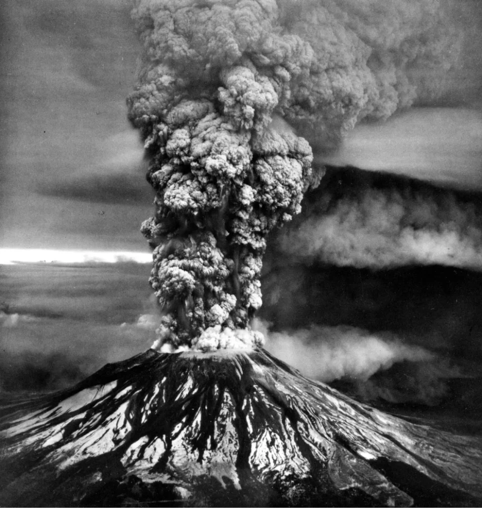
It was the largest subaerial landslide in recorded history. Molten rock, rich in high-pressure gas and steam, exploded northward toward Spirit Lake in a scalding mix of lava and pulverized rock.
Snow, ice, and several glaciers on the mountain melted, resulting in mudslides (or lahars) that reached nearly 50 miles to the southwest.
Most of this slide was the consistency of cement and moved down the North Fork Toutle River, filling the valley up to 600 feet deep with avalanche debris.
An eruption column rose 15 miles into the atmosphere. The thermal energy released during the eruption was equal to 24 megatons of TNT—1600 times more powerful than the bomb that destroyed Hiroshima at the end of World War II—and it destroyed 230 square miles of forest in three minutes.
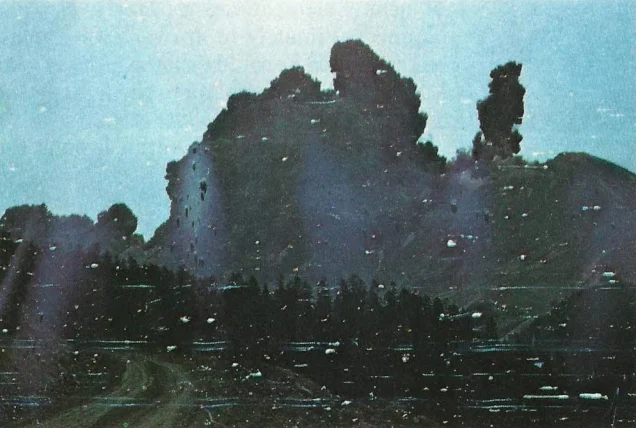
Robert Landsburg had his camera perched on a tripod and began snapping pictures of the enormous pyroclastic clouds emanating from the volcano.
Realizing there was no way to escape the encroaching cloud, Robert got into his car and continued to snap photos through his window from the front seat, giving himself just enough time to protect the film he was about to give his life for.
He rewound the film into his case, placed the camera in its bag, and put the bag in his backpack next to him on his car seat.
Then, as a 660-degree pyroclastic flow that was filled with gas and debris barreled toward his parked car, Robert laid his body on top of the backpack to protect it from the shower of ash.
Seventeen days later, Robert’s car buried in ash up to the windows, his body, and the backpack with his camera, were found near Sheep Canyon on the South Fork Toutle River.
The precious film was developed, and the images were published in the January 1981 issue of National Geographic.
Although the photos were damaged by the heat warping the camera and the ash that managed to find its way into the case, they reveal a truly terrifying glimpse of Earth’s fury.
Moreover, once they were published, it allowed all of humanity to see exactly what Robert Landsburg saw moments before he perished.
The official death toll for the explosion at Mount St. Helens is 57. Besides Robert Landsburg, volcanologist David Johnston, photographer Reid Blackburn, and amateur radio operator Gerry Martin all lost their lives trying to contribute to the science and study of volcanos.
In total, the Mount St. Helen’s disaster destroyed 200 houses, 27 bridges, 15 miles of railways, 185 miles of highway, and obliterated millions of fish and thousands of large game animals like elk and deer.
The eruption on May 18th, 1980, was the deadliest and most economically destructive volcanic eruption in the history of the contiguous United States.
Ash contaminated oil systems and caused short circuits in electrical transformers, resulting in blackouts. Air travel was disrupted in some instances for up to two weeks.
Over a thousand commercial flights were cancelled. As much as 540 million tons of ash fell over the Northwest, reaching as far away as Montana.
Mount St. Helens erupted five more times between May and October of 1980, most resulting in ash clouds and a fury of seismic activity. From 2004 to 2008, Mount St. Helens was once again active with a continuous gradual extrusion of magma.
While these eruptions were much smaller in scale, they were a reminder that the mountain may sleep, but she could awaken at any moment.
Today, Mount St. Helen’s stands 1,280 feet shorter than it did on May 17th, 1980.
The blast created a horse-shoe-shaped crater one to two miles wide and 2,100 feet deep. Forty-three years after the eruption, floating log mats of broken trees still exist on Spirit Lake and St. Helens Lake.
In a testament to the cycle of the death and rebirth of our planet, animals have now returned to the mountain. Grasses, shrubs, flowers, and even some trees have sprung from the ashes.
Sources
https://www.britannica.com/place/Mount-Saint-Helens


Leave a comment