Prior to 1980, Mount St. Helens was a popular vacation destination with hiking trails, camping sites, and stunning views.
The surrounding virgin forests provided a habitat for a diverse range of wildlife, including elk, deer, and black bears. The area was also home to numerous streams and rivers, teeming with fish and other aquatic life.
For weeks before the eruption, tremors and steam had hinted that the volcano was waking up. But nothing could have prepared the world for the sheer power and devastation that Mother Nature was about to unleash.

On the morning of May 18th, the volcano, which had been asleep for 123 years, roared back to life in a violent eruption.
Formation Of Mount St. Helens
Mount St. Helens is part of what is known as the Cascade Range, a volcanic arc stretching from Northern California to British Columbia. It emerged as a volcanic peak around 40,000 years ago.
Throughout its history, the volcano has erupted several times, the most recent prior to 1980 was back in 1857.
The volcanic activity inside Mount St. Helens is fueled by the subduction of the Juan de Fuca tectonic plate beneath the North American plate.
The Juan de Fuca plate is a relatively young oceanic plate that is constantly being formed at the Juan de Fuca Ridge, which is located off the coast of North America.
As new crust is formed and drifts away from the ridge, it cools and becomes denser. When the two massive plates come into contact with each other the Juan de Fuca plate is forced beneath the North American plate in a process known as subduction.
As the Juan de Fuca plate descends into the Earth’s mantle, the intense heat and pressure cause it to melt, generating magma and steam from the ocean water.
This molten rock and steam rises through the crust, squeezing its way through cracks and fissures in the rock where it reaches the surface in a volcanic eruption.
The magma that fuels Mount St. Helens’ eruptions is primarily silica-rich, making it thick and viscous. This magma builds up within the volcano until it erupts in a violent explosion.
The ongoing subduction of the Juan de Fuca plate not only produces the magma that builds inside Mount St. Helens, but it also triggers earthquakes and other geological activity in the region.
Warning Signs
In the weeks and months leading up to the 1980 eruption, a series of warning signs hinted at the volcano’s reawakening.
Increased Seismic Activity: Starting in March 1980, there was a dramatic increase in the number and intensity of earthquakes beneath the volcano. This meant that magma was moving upwards and increasing pressure within the mountain.
Ground Deformation: The north flank of Mount St. Helens began to bulge outward, growing at an alarming rate. This was a clear sign that magma was accumulating beneath the surface, pushing the mountain’s side outward.
Phreatic Eruptions: Small steam explosions occurred as the rising magma interacted with groundwater, further signaling increasing volcanic unrest.
These signs attracted the attention of geologists and volcanologists from across the country.
Researchers from the United States Geological Survey (USGS) and other institutions quickly converged on Mount St. Helens, establishing a network of monitoring stations to closely track the volcano’s activity and warn the public of any impending danger.
Mount St. Helens Eruption Timeline
As scientists studied the volcano, they predicted that it would erupt in a traditional vertical eruption and only affect a small area around the base of the mountain. In such a remote location, the damage to human life would be minimal, but Mother Nature had other plans.
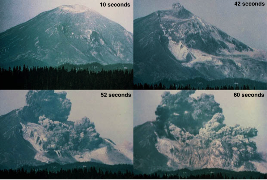
At precisely 8:32 AM on May 18, 1980, a magnitude 5.1 earthquake shook the mountain, causing the already weakened north face of Mount St. Helens to collapse in the largest debris avalanche in recorded history.
This landslide triggered the release of the pent-up pressure within the volcano.
Instead of erupting straight up into the air, the gas and maga shot out sideways with a force equivalent to roughly 24 megatons of TNT, which is about 1,600 times the power of the atomic bomb dropped on Hiroshima during World War II.
The lateral blast shot superheated gas and rock debris down the sides of the mountain and into the surrounding forests at speeds exceeding 600 miles per hour, instantly obliterating everything in its path. In a matter of seconds, 300 square miles of ancient virgin forest was flattened.
The towering plume of ash and pumice darkened the skies for hundreds of miles around, raining down ash like a gritty, suffocating snow. In 15 days, the ash cloud had circled the globe.
At the top of the mountain, centuries old snowpack and glaciers were exposed to the intense heat and melted rapidly, triggering massive lahars.
These volcanic mudflows surged down river valleys, carrying a slurry of mud and debris. These lahars altered the course of rivers, destroyed bridges, and engulfed entire communities in a thick, suffocating mud.
After nine hours of eruptions, the once lush landscape was transformed into a barren wasteland, stripped of vegetation, scarred by deep ravines, and choked by layers of ash and debris.
Immediate Impact
The eruption of Mount St. Helens decimated the surrounding area. The lateral blast instantly claimed the lives of 57 people, including volcanologist David Johnston, who had been monitoring the volcano’s activity from an observation post.
The ash column darkened the skies for hundreds of miles and rained down like a suffocating snow, burying towns and cities. Transportation systems were paralyzed, airports closed, and roads became impassable.
The economic impact was staggering, with timber, agriculture, and tourism industries suffering heavy losses.
Environmental Effects
The eruption of Mount St. Helens transformed the landscape and ecosystems in ways both destructive and regenerative. The obliteration of vast swaths of forest by the lateral blast and pyroclastic flows resulted in a sterile landscape devoid of vegetation.
The ash fall, which blanketed the region, choked waterways, and smothered plant life, further disrupting the delicate ecological balance.

While volcanic eruptions can obliterate entire ecosystems in the short term, they also enrich the soil with vital nutrients, laying the foundation for the emergence of new life.
Life Returns
Despite decimating forests and reshaping rivers and lakes, life always finds a way. Rising from the ashes and scorched earth, nature has gradually reclaimed the ravaged land. Pioneer species have paved the way for the return of diverse plant and animal life.
Within months of the eruption, plant species like lupine and fireweed began to emerge from the scorched earth. These early plants stabilized the soil and paved the way for the return of other plant life.
Over time, more and more plant communities gradually reclaimed the barren landscape, leading to the establishment of new forests.
The eruption also had a profound impact on the region’s waterways. Melted glaciers and snowpacks created new lakes and ponds. Lahars, those powerful mudflows, reshaped river valleys, depositing vast quantities of sediment and altering their courses.
Before the eruption, Spirit Lake covered approximately 1,300 acres. After the eruption, due to the massive landslide that damned its outlet, the lake expanded to a staggering 2,200 acres. Even after 40 years, logs from the blast still form a mat over 20% of the lake’s surface.
In the years since the eruption, scientists have observed a diversity of life returning to Mount St. Helens. Insects, birds, and mammals have recolonized the area, adapting to the altered landscape and finding new niches within the emerging ecosystems.
The eruption of Mount St. Helens is a great example of how volcanoes can be both destructive and a force of creation.
Lessons Learned
The 1980 eruption of Mount St. Helens was the most well-documented volcanic eruption up to that time, and remains one of the most thoroughly studied eruptions in history.
It not only revolutionized our understanding of the volcanic processes but gave scientists a new found respect for these powerful forces. The data collected has been invaluable in developing a better understanding of volcanic behavior and improving eruption forecasting.
The eruption also served as a natural laboratory for studying how ecosystems recover after a devastating event.
The eruption of Mount St. Helens highlighted the critical need for advanced volcano monitoring and early warning systems to protect lives and property. It showed the importance of effective communication and evacuation plans to ensure the safety of communities living in volcanic regions.
While volcanoes are capable of unleashing unimaginable destruction, they also play a vital role in the Earth’s dynamic ecosystem. They are a stark reminder of Earth’s ancient raw power and the never-ending cycle of destruction and creation that shaped our planet’s primordial past.
Sources
https://www.history.com/this-day-in-history/mount-st-helens-erupts-2
https://en.wikipedia.org/wiki/Mount_St._Helens
https://www.usgs.gov/volcanoes/mount-st.-helens/science/1980-cataclysmic-eruption


Leave a comment